On May 18th 2007 my wife and me started the island crossing with minimal equipment (15 kg), drinking water for the first 2 days (10 l) and food for about 3 days (4 kg).
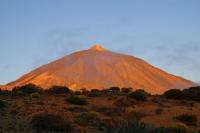
From San Juan de la Rambla at sea level we started a steep ascent. After leaving civilisation we passed numerous abandoned terrace-fields and at an elevation of 1000 m we entered the forest belt and the mist. At 2000 m we left forest and mist again, reached the sunny and arid Teide National Park near Riscos de la Fortaleza and continued to El Portillo to replenish our water stock. From there we followed the trail to the summit of Pico del Teide 3718 m via Montaña Blanca and Refugio Altavista 3270 m. Accompanied by snowfall and surrounded by clouds we reached the top of the crater. On the way down to Boca Tauce we crossed Pico Viejo 3135m. From Parador Nacional we crossed Ucanca Pass 2468 m from where we constantly hiked down (again crossing forest and mist) back to sea level via Vilaflor and San Miguel to Los Abrigos. The last part we hiked along the shore to Playa de las Americas.
In 7 days we covered a distance of 140 km with an elevation difference of 5300m.
The slides of this north-south cross-section are presented in chronological order, enjoy them as we did!
Tenerife offers not only sun, fun and nightlife, it is also a paradise for hikers.
On May 18th 2007 my wife and me started the island crossing with minimal equipment (15 kg), drinking water for the first 2 days (10 l) and food for about 3 days (4 kg).
From San Juan de la Rambla at sea level we started a steep ascent. After leaving civilisation we passed numerous abandoned terrace-fields and at an elevation of 1000 m we entered the forest belt and the mist. At 2000 m we left forest and mist again, reached the sunny and arid Teide National Park near Riscos de la Fortaleza and continued to El Portillo to replenish our water stock. From there we followed the trail to the summit of Pico del Teide 3718 m via Montaña Blanca and Refugio Altavista 3270 m. Accompanied by snowfall and surrounded by clouds we reached the top of the crater. On the way down to Boca Tauce we crossed Pico Viejo 3135m. From Parador Nacional we crossed Ucanca Pass 2468 m from where we constantly hiked down (again crossing forest and mist) back to sea level via Vilaflor and San Miguel to Los Abrigos. The last part we hiked along the shore to Playa de las Americas.
In 7 days we covered a distance of 140 km with an elevation difference of 5300m.
The slides of this north-south cross-section are presented in chronological order, enjoy them as we did!
Tenerife offers not only sun, fun and nightlife, it is also a paradise for hikers.
|